
By: Peter Srajer, CLS, P. Eng. and Benjamin Skogen, CPM
Summary
Trimble Catalyst is a software based GNSS receiver as opposed to the use of the dedicated processors and firmware programming that is on board a conventional hardware receiver. The Trimble Catalyst uses the DA1 antenna and processing power of a compatible mobile device to acquire, track and process GNSS signals. Catalyst is an on-demand, subscription user-based service. Using the service, any location-enabled Android field app can use various levels of positioning without the need for additional hardware or additional correction services (depending on location). The software is only available on Android based systems at this point, Apple iOS has technical limitations which preclude it’s use, primarily the lack of support for OTG (on the go) USB protocols and limitations on CPU and GPU coprocessing that are needed for continuous signal processing and tracking. Windows OS would be sufficient technically but is not supported at this point due to its limited market penetration in this space.
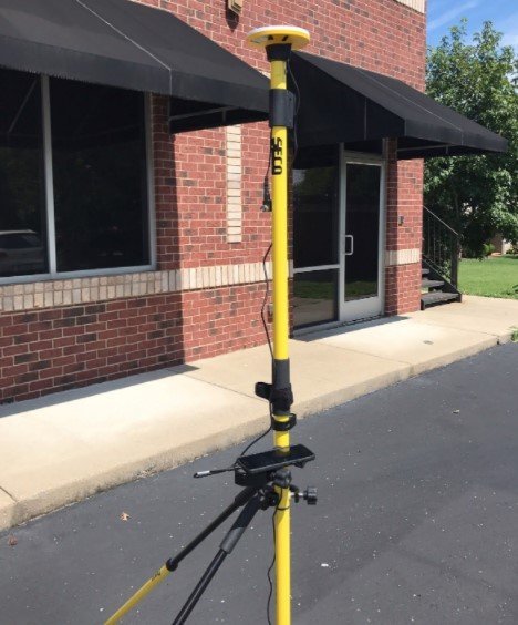
The critical piece of the solution is the DA1 USB antenna that can acquire and track multi-frequency GNSS satellites and correction services. (GPS/GLO/GAL/QZSS/L-bands). The DA1 will perform the initial signal acquisitions (GNSS and Correction services) and transfer the signal tracking to the mobile device which then is used to compute the final positioning solution.
Catalyst allows worldwide access to Trimble’s correction services through Trimble Corrections Hub, which also bundles access to the Trimble VRS Now and Trimble RTX correction services (See Appendix A for Details). These correction services are the critical part of the solution and the availability of the higher accuracy solutions is dependant on subscribed access to these services and on your location. You do not need access to local network or cellular services, the Trimble correction services are available over a satellite link. It will also support the use of third-party correction services using the NTRIP protocol, these may require connectivity and third party subscriptions to those services.
Historical and Technical Basis
Software based receivers started as an idea in the mid 2000’s and have become possible due to the ability of the underlying off the shelf hardware to support the software algorithms needed for digital signal processing. GNSS signal acquisition and tracking is an extremely computationally intensive process and normally would require dedicated hardware and firmware specifically designed to handle the real time processing of large data flows and signal processing algorithms.
A standard GNSS receiver is a collection of dedicated hardware components, the core of which is an Application Specific Integrated Circuit (ASIC): this is often a very large proprietary chip on the GNSS boards at the heart of hardware based receivers. These boards typically host several other dedicated hardware components. Each manufacturer has one or more flagship GNSS boards (e.g., for Trimble there are popular boards like the BD970 with a large ASIC on it running their Maxwell technology). Or, an increasing number of third-party manufacturers use OEM boards produced by firms like Trimble; for example, Bluestar uses a board produced by Hemisphere, Leica uses boards produced by Novatel (now Hexagon)
The use of more efficient and faster linear algebraic mathematical libraries, calculus and matrix functions has allowed software to reach the point where they can compete with hardware-based solutions enough to process GNSS data. Similar mathematical algorithms are used in powering AI and Machine learning systems and are considered one of the unsung engineering breakthroughs of the last decade.
The advantage of a software based receiver lies in its flexibility, it can be updated and enhanced on a ongoing basis and as new signals and services come up, it can be updated to use those where a hardware system is limited in its ability to upgrade without a expensive factory or laboratory process. Other advantages over the legacy dedicated hardware units, especially in flexibility, are that new constellations, signals, and advances in GNSS algorithms can be added with a simple software upgrade. This makes the marketing push over how many channels a receiver can handle irrelevant.
The limitation is processing power, and it’s likely that smartphone processing capabilities will advance fast enough (or even faster) than changes in GNSS technology. An Achilles heel in GNSS solutions is the antenna: there are physical limitations. If you are receiving garbage, rife with multipath, random or bias signal noise, you will process garbage. The GPS antenna in your smartphone is terrible as a surveying or engineering tool. A ground plane to mitigate multipath is essential, and antenna size is also a function of the nature of the signals, an all purpose antenna in a mobile device that receives cellular, WIFI, Bluetooth and GNSS signals is going to prioritize design on the cellular or WIFI signal structure primarily. Physical engineering limits, signal structure and frequency preclude the ability of an all-purpose antenna to support all purposes to the extent needed for high precision and high accuracy engineering solutions.
There are also Chu limits to consider (thresholds on how much signal and the noise ratio certain sized elements can receive). A GNSS receiver paired with a tiny or poorly engineered antenna limits the accuracy and productivity that can be expected, this is the reasoning for the requirement of the dedicated Trimble DA1 antenna.
Trimble Catalyst requires three components:
- A location-enabled mobile app on an Android device
- A subscription to the Catalyst service (Cost runs from $10/hour for on demand 1 cm – > Free for 2-3 metre) See below for cost details
- A Trimble DA-1 antenna that plugs directly into an Android smartphone or tablet USB port ($350)
The field mobile device (Android based in this case) can run custom applications that leverage the Trimble SDK or can be setup to use Android Location Sharing service by the mobile mapper software to directly stream positioning information. The use of the SDK would give a more flexible software solution and will expose more functionality and ability to access the precision and accuracy factors and well as items such as the expected satellites in view, ability to configure services etc.
The minimum hardware requirements are: (Source: Trimble.com)
- Android 5.0 or higher
- 64-bit CPU with at least 4x Arm® cores (6x or more Arm cores recommended)
- Maximum Core speed of at least 1.5 GHz
- 5 GB of RAM or higher
These requirements would include most any Android device from the past 3-4 years, testing by Trimble has been completed and verified on units including the Samsung Galaxy S5 and S6 units which indicates the minimum level of mobile devices expected. Essentially what Trimble has done is taken their core GNSS technology that runs on a dedicated hardware chip and created a software service that can run in an app on a smartphone or tablet. The user must select a monthly subscription based on the level of accuracy desired.
Accuracy Levels
There are four levels of software subscription to choose from, depending on what kind of work you are doing. The subscription prices go up with the levels of precision needed. A subscription gives the user the ability to access the Trimble Corrections Hub and access to the Trimble corrections services. In an online environment the Corrections Hub uses the Trimble RTX or VRS corrections over the internet, in offline mode this switches to the RTX or VRS satellite broadcast corrections using the DA1 antenna.
- Meter provides code-processing using the correction data from Trimble’s RTX service. It tries to get code data from the RTX online service first, but if there is no internet connection it can get the data from the geostationary L-Band satellites that transmit RTX corrections. It can also use an SBAS solution if the other sources are not available. The DA1 antenna provides the L-Band satellite connectivity in cases of no network connection. The cost of this service is $40 per user per month
- Sub-meter uses the same RTX code correction sources and in the same manner as the meter option, but the higher subscription rate unlocks the precision. With online code data, it tends to get 30cm-60cm, and with sat-based code data it is slightly less precise: 40cm-60cm. The cost of this service is $120 per user per month.
- Decimeter uses RTK and/or Network RTK sources. If a user is in an area serviced by Trimble’s VRS Now networks (parts of the U.S. south and Midwest, most of western Europe, parts of Australia, etc.),(see coverage map later) corrections are delivered via internet connection and are included in the subscription. If you are in a non-VRS Now area, you can connect to local, regional, or state real-time networks (some are free, and others charge) or get RTK corrections from an I.P.-enabled base (Can be setup on a per project basis). This level of subscription unlocks the processing capability for decimeter precision. The cost of this service is $200 per user per month.
- Precision level unlocks the processing of full-on RTK/Network RTK, in the range of 1-2cm within the decimeter solution above. It can use non-proprietary RTK formats, like RTCM-3. It also supports RTCM-3 MSM (Multi-Service Message) for multiple constellations. This is essentially a higher-level processing solution than the Decimeter subscription; it uses the same correction sources and signals as the Decimeter level. The cost of this service is $350 per user per month.
As a subset of the Precision level, there is a Precision-on-Demand solution which provides the same level of accuracy and processing as the Precision subscription, but the on-demand subscription is based on a hourly usage (Positioning as a Service). This level costs $10/hour in 10 hour blocks and can be shared among any number of users.
Catalyst can feed live positions directly to the mock location apps within the mobile devices. They also offer a software development kit (SDK), which is freely available, and supports Catalyst. The GNSS Direct SDK (same SDK as for their R1 and R2 receivers) is available for third parties to use to integrate their software solutions with Catalyst. This SDK is most likely the best solution to integrate the Prostar solutions within the Trimble hardware ecosystem. There is more to this partnership than the technical ability to have a robust high precision solution that has the advantage of easy configuration in the field. Trimble has significant worldwide presence and partnering with them is a great opportunity to leverage that presence as a trusted partner. Many large corporations in the engineering and surveying sectors have embedded interest with the Trimble ecosystem, this allows an easier introduction and transition into their survey and engineering departments and a level of comfort to the engineering groups that the solution is trusted. This is a significantly less expensive solution initially than buying conventional hardware receivers, setting up VRS or other correction subscriptions and dealing with upgrades and configurations to the hardware.
Information and documentation on the SDK are located at: https://developer.trimble.com/catalyst/
The SDK supports both Xamarin (C#) and Java environments or would allow the use of either to bridge to another development language. Detailed information, the SDK and examples are located at the Trimble site. The SDK is located at: (You will need a Trimble ID – free) to access: https://community.trimble.com/community/developer/geospatial-developers/trimble-precision-sdk-for-trimble-catalyst
Appendix A – Coverage Maps for each Service Level
Source: Trimble Website – Valid as of Dec 12, 2019

Figure 2- Meter Precision Coverage Map
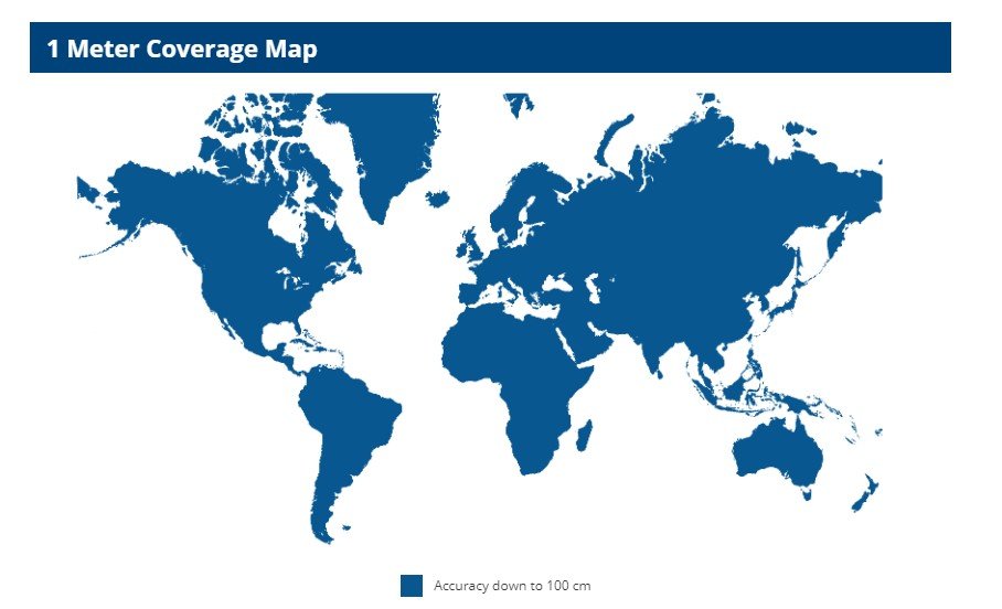
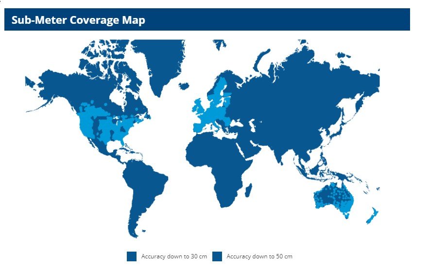
Figure 3- – Sub- Meter Precision Coverage Map
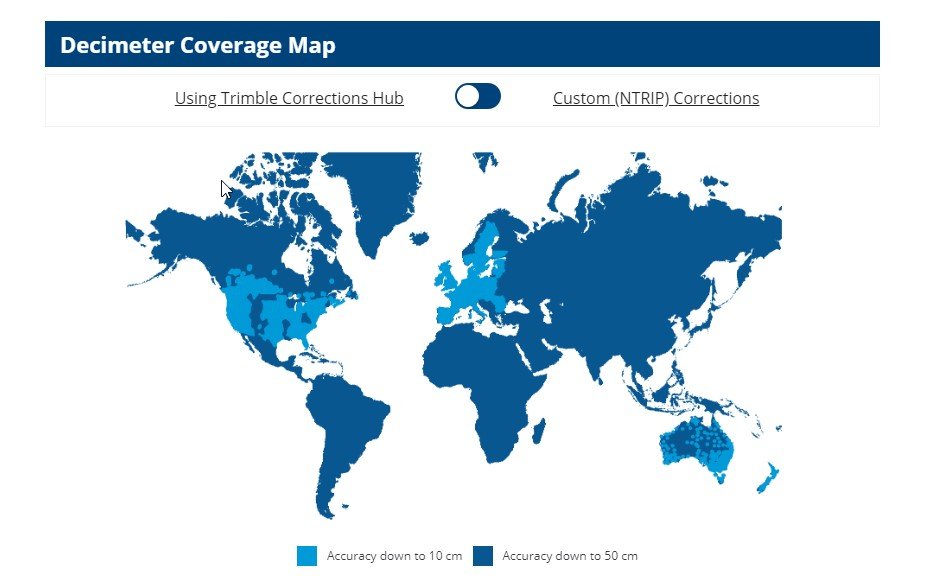
Figure 4 – Deci-Meter Precision Coverage Map
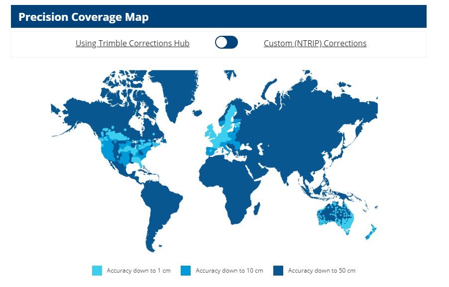
Figure 5- Centimeter Precision Coverage Map
Trimble RTX and VRSNow
Coverage for the Precision and the Precision-on-Demand subscription levels are the same, the difference is in how the subscription is charged. Coverage areas for the other subscriptions are similar as well, it is only the processing to retrieve the higher level of precision that changes the cost, the physical coverage area is the same. The higher levels of precision shown in Western Canada and Southern Ontario are due to the recent acquisition of the Can-Net VRS network and are considered very reliable and robust.
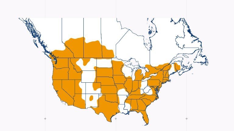
Figure 6 – RTX Coverage Detail – North America
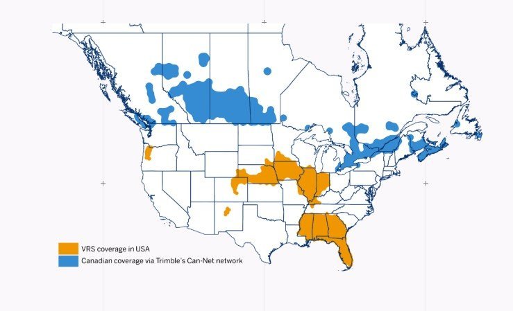
Figure 7 – VRS Coverage Detail – North America
VRS service coverage corresponds to the higher accuracy 1 cm level of subscription availability, RTX is Trimble’s decimeter and better level of service.